GPSで面積 1.2024.0226
Continue to app
Free Version
Publisher Description
GPSで面積 - Calculate the area that gets the current position in GPS, enclosed. Also, you can not just GPS, it also calculates the distance and area of the map.
This app calculates the area and distance based on the latitude and longitude obtained from GPS.
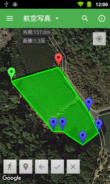
When you want to find out the area, walk around the perimeter on site and mark when you come to a corner.
When you reach the final corner, calculate the area enclosed by the marker.
It can be used to measure the area of land, buildings, etc., and the distance of routes, walking, golf, etc.
Basic usage
1. Press the "Mark at current location" button to add a marker at your current location.
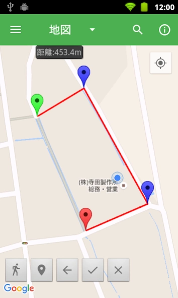
2. Every time you add a marker, a line is drawn and the distance is displayed.
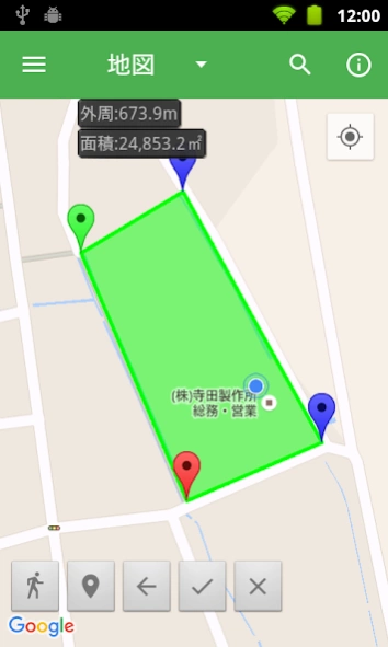
3. Click the "Calculate area" button to display the area surrounded by markers.
The distance at this time will be the perimeter of the selected area.
*Area is not displayed correctly in areas where lines intersect.
* You can mark up to 500 markers.
Detailed usage
・From the left, the buttons on the bottom left are "Tracking", "Mark current location", "Clear one", "Calculate area", and "Clear all".
・Start tracking with the "Tracking" button.
・A marker will be added to your current location at regular intervals until you press the "Tracking" button again.
・Add a marker to your current location with the "Mark at current location" button.
・Clear the last marked marker with the "Clear One" button.
- Display the area and perimeter of the area surrounded by markers with the "Calculate area" button.
・The start point (green) and end point (red) do not need to be connected. Add it as the last edge when calculating the area.
- Clear all markers and area areas with the "Clear All" button.
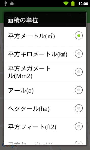
・You can change the unit of area and the unit of distance with the menu button.
・Usable area units
square meters, square kilometers, square mm, ares, hectares, square feet, square yards, acres, square miles,
Tsubo, Ridge, Tan, Machi, Tokyo Dome
・Usable distance
m, km, feet, yards, miles, between, towns, ri
- Related units can be automatically converted to the most suitable unit.
・Automatic unit conversion can be enabled or disabled with the option "Automatic unit adjustment".
・You can save the marker displayed on the screen with the menu button.
- You can call the saved marker with the menu button.
- You can search by entering the place name, address, name with the search button.
Also, since Google maps are displayed on the screen, you can calculate the area simply by marking it on the map.
・The operation of the map conforms to Google maps.
・ Add a marker to the location by long tapping the map.
・Tap the marker to display the marker number and latitude and longitude.
- Long tap the marker and drag to move the marker.
・The map can be switched between "Map", "Aerial Photo", and "Terrain".
*The area is calculated as the area of a sphere surrounded by geodesics, with the earth as a sphere of 6,378,137m.
It does not take into account altitude, slope, etc.
*Distance is obtained from Google maps API after considering geodesic curves.
* Since the accuracy of GPS depends on the terminal, if you are concerned about the position acquired,
Please respond by moving the marker.
_/_/_/_/_/ End of support for Android less than 5.0 _/_/_/_/_/
Thank you for using "Area by GPS".
We have important information for customers using the Android app.
We have decided to end support for devices with Android 5.0 or lower.
If your device's OS is less than 5.0, you will not be able to update to the latest version.
・How to check the OS version
"Settings - Device information - Android version"
Support will be discontinued, but installed apps will continue to work.
If you have any questions, please contact us from our website.
We apologize for any inconvenience this may cause, and appreciate your understanding.
About GPSで面積
GPSで面積 is a free app for Android published in the Geography list of apps, part of Education.
The company that develops GPSで面積 is 株式会社寺田製作所. The latest version released by its developer is 1.2024.0226.
To install GPSで面積 on your Android device, just click the green Continue To App button above to start the installation process. The app is listed on our website since 2024-02-25 and was downloaded 0 times. We have already checked if the download link is safe, however for your own protection we recommend that you scan the downloaded app with your antivirus. Your antivirus may detect the GPSで面積 as malware as malware if the download link to jp.web_terada.Android.GPSArea is broken.
How to install GPSで面積 on your Android device:
- Click on the Continue To App button on our website. This will redirect you to Google Play.
- Once the GPSで面積 is shown in the Google Play listing of your Android device, you can start its download and installation. Tap on the Install button located below the search bar and to the right of the app icon.
- A pop-up window with the permissions required by GPSで面積 will be shown. Click on Accept to continue the process.
- GPSで面積 will be downloaded onto your device, displaying a progress. Once the download completes, the installation will start and you'll get a notification after the installation is finished.
